The Outdoor Map Ends at the Door
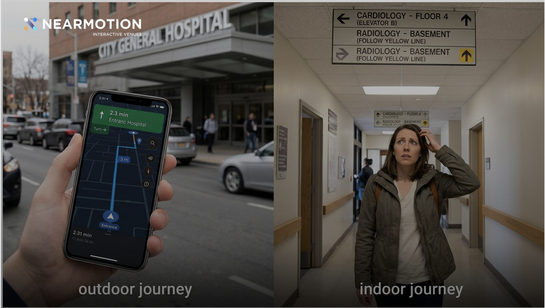
Outdoor navigation is a solved problem. It will take you across a continent and drop you at the right entrance almost every time. The reason visitors still get lost is simpler and more uncomfortable: the indoor half of the journey was never built.
Think about the last time you visited a large hospital, a new airport, or a sprawling mall. Your maps app performed flawlessly. It routed you around traffic, predicted your arrival to the minute, and delivered you to the entrance.
And then it stopped. Not because the technology failed, but because its job was done. You had reached the address.
The problem is that the address was never your destination. Your destination was Cardiology on the fourth floor of Building C. Gate B14, past two security checkpoints. A meeting room with a name nobody at reception recognizes. The hardest, most stressful part of your journey began at the exact moment your guidance ended, and from that point on, you were navigating a building the way people did in 1985: squinting at signs, asking strangers, and hoping.
This is the real gap in modern navigation. It is not a handoff glitch or a GPS limitation. It is that most venues have never created the indoor half of the visitor journey at all.
Outdoor Navigation Did Its Job. Then the Journey Went Dark
It is tempting to frame this as a technology failure: GPS cannot penetrate concrete, so navigation "breaks" indoors. That framing misses the point, because it assumes someone built an indoor experience for GPS to hand over to.
Usually, nobody did.
Google and Apple mapped the world's roads down to the lane. Cities invested in addressing systems, traffic data, and transit feeds. The outdoor journey is the product of decades of coordinated effort. The indoor journey, by contrast, belongs to each individual venue, and most venues have never treated it as their responsibility. Their buildings exist on the global map as a single pin and an outline. Everything inside that outline, the floors, departments, clinics, gates, shops, and rooms where visitors actually need to go, is digitally invisible.
So the visitor's experience splits in two:
- Street to entrance: live guidance, accurate timing, rerouting, total confidence.
- Entrance to destination: no map, no position, no route. Static signage designed years ago, and whatever help a stranger can offer.
The contrast is jarring precisely because the first half works so well. Visitors arrive trained by outdoor navigation to expect continuous guidance, then cross a threshold into a complex environment where none exists.
Why the Indoor Half Was Never Built
If the gap is this obvious, why does it persist in most large buildings? A few reasons come up again and again.
The pin was mistaken for the map. For years, being findable meant having a correct address and a pin on Google Maps. Venues checked that box and considered navigation handled, without distinguishing between being reachable and being navigable.
Floor plans were confused with maps. Almost every building has floor plans. But a CAD drawing or a fire-evacuation PDF is documentation, not navigation. It has no live position, no routing logic, no awareness of elevators, accessibility paths, or temporary closures. A visitor cannot follow a blueprint.
Signage was assumed to be enough. Physical signs are necessary, but they are static, language-limited, and notoriously hard to maintain across renovations. Research on wayfinding in hospitals has shown for decades that signage alone fails in complex multi-building environments, which is why "can you walk me there" remains the most common request at any information desk.
Nobody owned the visitor's indoor journey. Facilities teams own the building. Marketing owns the app. IT owns the infrastructure. Operations owns the front desk. The end-to-end experience of a person moving from the entrance to a room cuts across all of them and traditionally belonged to none.
It looked harder than it is. Indoor mapping once meant long surveying projects and dense hardware installations. That reputation outlived the reality. Modern indoor mapping has become dramatically faster and lighter, but many decision-makers are still pricing the version that existed a decade ago.
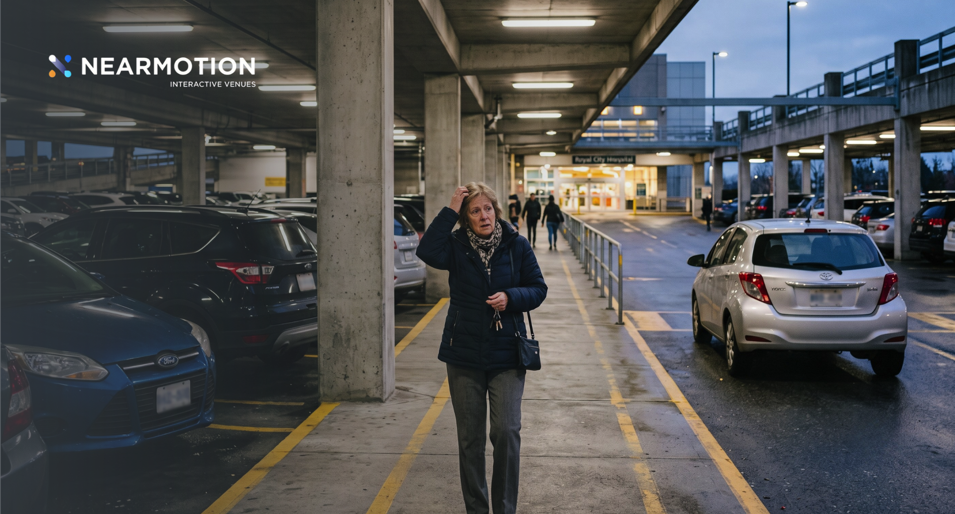
What Visitors Actually Face at the Door
The cost of the missing indoor half is easiest to see from the visitor's side, and it varies by venue:
- Hospitals. A patient arrives on time thanks to outdoor navigation, then spends fifteen minutes finding the right wing, floor, and clinic. Wayfinding studies have consistently tied this confusion to late arrivals, missed appointments, and elevated patient anxiety, especially for elderly visitors and first-timers.
- Airports. Passengers cannot judge the real distance to their gate, so they skip food and retail and go wait, just in case. The uncertainty, not the walk itself, shapes their behavior.
- Universities. New students and visiting parents navigate dozens of buildings with internal room codes that appear on no public map.
- Malls and event venues. Visitors who cannot find a specific store or hall settle for what is in front of them, and exhibitors in hard-to-find locations quietly lose traffic.
- Corporate offices. Guests are escorted by staff because there is no alternative, a small ritual that consumes hundreds of work hours a year in any large headquarters.
In each case, the building is not badly designed and the visitor is not careless. The indoor journey simply has no infrastructure behind it.
What the Indoor Half of the Journey Looks Like
Completing the visitor journey means giving the inside of a building the same digital foundation the outside already has. In practice, that foundation has four layers.
1. A real indoor map
Not a floor plan, but a structured, navigable digital map: every floor, corridor, room, elevator, escalator, and point of interest, modeled with routing logic and kept current as the building changes. Open standards such as Apple's Indoor Mapping Data Format (IMDF) exist specifically to make indoor spaces machine-readable, the same way road data made cities routable.
2. Indoor positioning
A map becomes navigation when it knows where the visitor is. Indoors, that position comes from technologies suited to the environment: Bluetooth Low Energy beacons, Wi-Fi based positioning, geomagnetic fingerprinting, or camera-based visual positioning. Combined with the phone's own motion sensors, these keep a live, accurate position on the indoor map, including which floor the visitor is on, something outdoor systems were never designed to know.
3. Wayfinding, not just location
Knowing where you are is not the same as knowing how to get somewhere. True indoor wayfinding plans routes the way outdoor navigation does: step by step, floor to floor, with accessible alternatives for visitors who need elevators instead of escalators, and with the ability to reroute around a closed corridor the same day it closes.
4. Continuity with the outdoor journey
Once the indoor half exists, the two halves can finally connect. A visitor sets one destination, "Dermatology, Building C," and the journey runs as a single route: the drive, the best entrance, and the indoor path to the department door. The often-discussed indoor-outdoor handoff turns out to be the easy part. The hard part, and the missing part, was always the indoor world itself.
A Quiet Shift Is Underway
The gap is starting to close, and not only at flagship airports. Several forces are converging:
- Expectations have hardened. A generation raised on turn-by-turn guidance experiences an unmapped building as broken, not normal.
- Mapping has become lighter. Creating and maintaining a navigable indoor map no longer requires months of surveying or heavy hardware grids, which moves indoor mapping from megaproject territory into the reach of ordinary hospitals, campuses, and malls.
- The data has a second life. Once a building is mapped and visitors can navigate it, venues gain something they never had: an honest picture of how people actually move through their space, which informs everything from signage placement to staffing to layout.
The pattern resembles what happened outdoors twenty years ago. Once a few cities and roads were properly mapped and routable, navigation went from novelty to expectation everywhere. Indoor spaces are at the beginning of the same curve.
The Bottom Line
The visitor journey does not end at an address, but for most buildings, the guidance does, because the indoor half of the journey was never created. That is not a failure of GPS or smartphones. It is an unfinished map.
Outdoor navigation kept its promise: it brings people to the door. What happens after the door is the venue's half of the story, and the venues that finish it will offer something visitors can feel within the first thirty seconds of walking in, even if they never name it: the journey simply never stops.
Frequently Asked Questions
Why do navigation apps stop working inside buildings?Two reasons. GPS signals degrade indoors because concrete and steel block satellite line of sight, but more fundamentally, most buildings have no digital indoor map for any app to navigate. Without a navigable indoor map, there is nothing for guidance to continue onto.
What is the difference between a floor plan and an indoor map?A floor plan is a static drawing made for construction or compliance. An indoor map is structured, machine-readable data with routing logic: it knows how corridors connect, where elevators and accessible paths are, and can support live positioning and turn-by-turn directions.
What is indoor wayfinding?Indoor wayfinding is the digital guidance of a person through a building to a specific destination, such as a clinic, gate, or meeting room, using an indoor map, live positioning, and step-by-step routing across floors.
How is a visitor's position tracked inside a building?Through indoor positioning technologies such as Bluetooth Low Energy beacons, Wi-Fi based positioning, geomagnetic fingerprinting, or camera-based visual positioning, usually fused with the smartphone's motion sensors to maintain a smooth, floor-aware position.
Does creating an indoor map require major construction or hardware?Not anymore. Modern approaches build navigable maps from existing floor plans and use lightweight or hardware-free positioning methods, which has reduced what was once a months-long infrastructure project to a far simpler deployment.
Can outdoor and indoor navigation work as one continuous journey?Yes. When a building's indoor map is georeferenced to global coordinates, a single route can run from the street to a precise indoor destination, including parking, the best entrance, and floor transitions.
Featured Success Stories
See how businesses like yours are leveraging Nearmotion to createimpactful indoor experiences.

.jpg)

Send Us a Message
Fill out the form below, and our team will get back to you shortly.


Find Your Perfect Solution
Ready to transform your retail space? NEARMOTION offers tailored solutions. Discuss with an expert or start building your map for free.