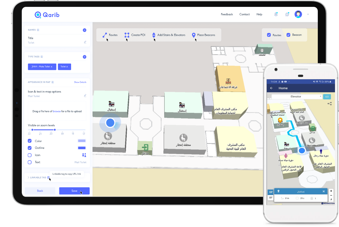
Digital Mapping Using MapStudio, Quick & Simple!
NEARMOTION has recently launched it digital mapping service for big buildings. Now, hospitals, universities, shopping malls, airports and museums can create their indoor maps, define routes and points of interest then take them to their mobile apps to provide visitors with great user experience. MapStudio supports maps in different formats:
- Images
- PDFs
- Customized 2D maps (Enterprises only)
- Customized 3D maps (Enterprises only)
Normally working on digital maps takes weeks of team work to prepare from AutoCAD format to a Geographical data in a form that allows smartphones to interact with. With MapStudio we have managed to reduced this to a one day work only.
GIS mapping is enhanced with open source tools that combine customer-specific and internal GIS solutions to process geodata in different formats and quickly convert data for specific needs. Geographic information systems offer the possibility to collect geographic data in a variety of formats, such as geodata, maps and maps of land, sea, air or water. [Sources: 0]
At that time, digital maps could only be accessed by complicated GIS programs, which limited their usefulness. With digital mapping, Gis tools thus collect certain levels of information that are not available on traditional maps. [Sources: 0, 5]
Google has made maps more developer friendly with its application program interface (APIs), which also improves the ability of users to scroll locations in the map view. With the growing number of digital card applications, digital maps have gained in importance in recent years. [Sources: 5]
The primary input data sets for digital geomorphological mapping include satellite images, demos and aerial photographs. Instead of relying on the eyes of local people, sensors and cameras collect map data and store it for future use. [Sources: 1, 5]
A recently collected data set from these sources is usually provided in a projected coordinate system with so-called spatial resolution. Raster data is typically a collection of images with a resolution of a few hundred pixels or less, typically in the 1,000 pixel range. As with ordinary digital photos, digital photos also have individual pixels (Figure 8) that represent the minimum resolution units of information defined by the resolution (i.e. the maximum resolution) of the digital image (Figure 9). [Sources: 1]
The data used for digital soil mapping is archived to retain the expertise used to predict soil distribution in the landscape. The aim of the sampling plan is to capture the variability of a landscape as represented by environmental data representing the soil – forming factors such as soil moisture, soil composition and soil type – as well as variability in the landscape through the presence of different types of soil and environmental factors. This data, which has been converted from a paper based on analogue format to a digital format, will be available for a wide range of soils and soils – specific applications, for example in agriculture, forestry, urban planning or landscape planning. [Sources: 1, 4]
This capability will enable soil scientists to present their soil knowledge to the user in a more comprehensive and thorough way in the current vector model. Traditional soil classes represent small segments of the landscape, and each layer represents the uncertainty. Each generation is associated with a different soil class, such as soil moisture, soil composition and soil type, as well as with different environmental factors. [Sources: 4]
Finally, potential users can be aware of the technology, understand how it works and be familiar with the technical aspects of their application in the field. This is particularly relevant for structure, movement and photogrammetry and, finally, the potential user can understand and understand the techniques and their implementation. To address this problem, we present an assessment in this paper that tests the use of high-resolution 3D mapping techniques to measure millimeter and centimeter-scaled deviations in topography. Our results show that they can be measured in the field with high-resolution 3D mapping, making them useful for a variety of applications, such as geographic mapping. [Sources: 2]
Public communication and education can be improved by providing high-resolution 3D map data with visual information. One of the major obstacles facing research groups in the public domain is the lack of easily interpretable visual data products generated by the use of high and low-resolution mapping techniques such as photogrammetry. So far, the barrier to public understanding of this technology and its application in this area has been low. [Sources: 2]
While sub-disciplines in ecology have made progress in using high-resolution remote sensing methods to answer questions and test ecological paradigms on a scale, these methods are still not being used enough in the public domain. [Sources: 2]
The Web of Science search conducted in December 2019 revealed that 23.7% (1031) were classified as “ecology,” compared to 23 (7,1031) classified as “multidisciplinary.” [Sources: 2]
The ability to accurately map ecosystems in three or more dimensions has changed the way we study ecosystem ecology and management. Advances in sampling technology have driven an ever-growing range of questions that can be asked about the natural world. In the field of 3D mapping, recent technological advances have led to the development of rapidly deployable remote sensing tools, including high-resolution satellite imagery (Figure 1) and digital 3D mapping. However, these techniques have become logistically inadequate, as detailed information is required due to limitations on data resolution, accuracy and cost. [Sources: 2]
GIS software can be used to create custom maps that cover an area and present features of particular interest to the user. A map of vegetation types is placed on a shaded relief map of the Earth’s surface to illustrate the relationship between biology and topography. There are a number of ways to create and use these maps, such as using geomapping software. [Sources: 3]
NEARMOTION has been the right partner for mega projects including Johns Hopkins Aramco Healthcare and Dallah Hospitals
For more information, please contact us today!
Sources:
[0]: https://www.intellias.com/digital-mapping-technology/
[1]: https://www.sciencedirect.com/topics/earth-and-planetary-sciences/digital-mapping
[2]: https://royalsocietypublishing.org/doi/10.1098/rspb.2019.2383
[3]: https://www.encyclopedia.com/earth-and-environment/geography/maps-and-mapping/digital-mapping
[4]: https://www.nrcs.usda.gov/wps/portal/nrcs/detail/soils/survey/geo/?cid=stelprdb1254424
[5]: https://www.gpsworld.com/a-milestone-in-digital-mapping/
Other news
Contact us
We are always open for new projects and ready to collaborate.


